Proposals
Key information about the site
Hill Residential is proud to be bringing forward proposals have been designed to reflect the character of the local area and meet the needs for local residents, while also creating well-connected, sustainable and inviting community spaces.
Key benefits
Proposals prepared to meet the local needs of Harpenden
The proposals present an opportunity to help deliver much needed housing whilst also delivering new green open space for new and existing residents to enjoy.
- A mix of circa 56 high-quality new homes, including circa 23 affordable homes and a mix of house types to help address local housing needs.
- Provision of high-quality public open spaces for recreation, play and enjoyment.
- Promotion of active travel through the site’s sustainable location, offering easy walking or cycling access to the Nickey Line, Harpenden Town Centre, schools, shops and the railway station.
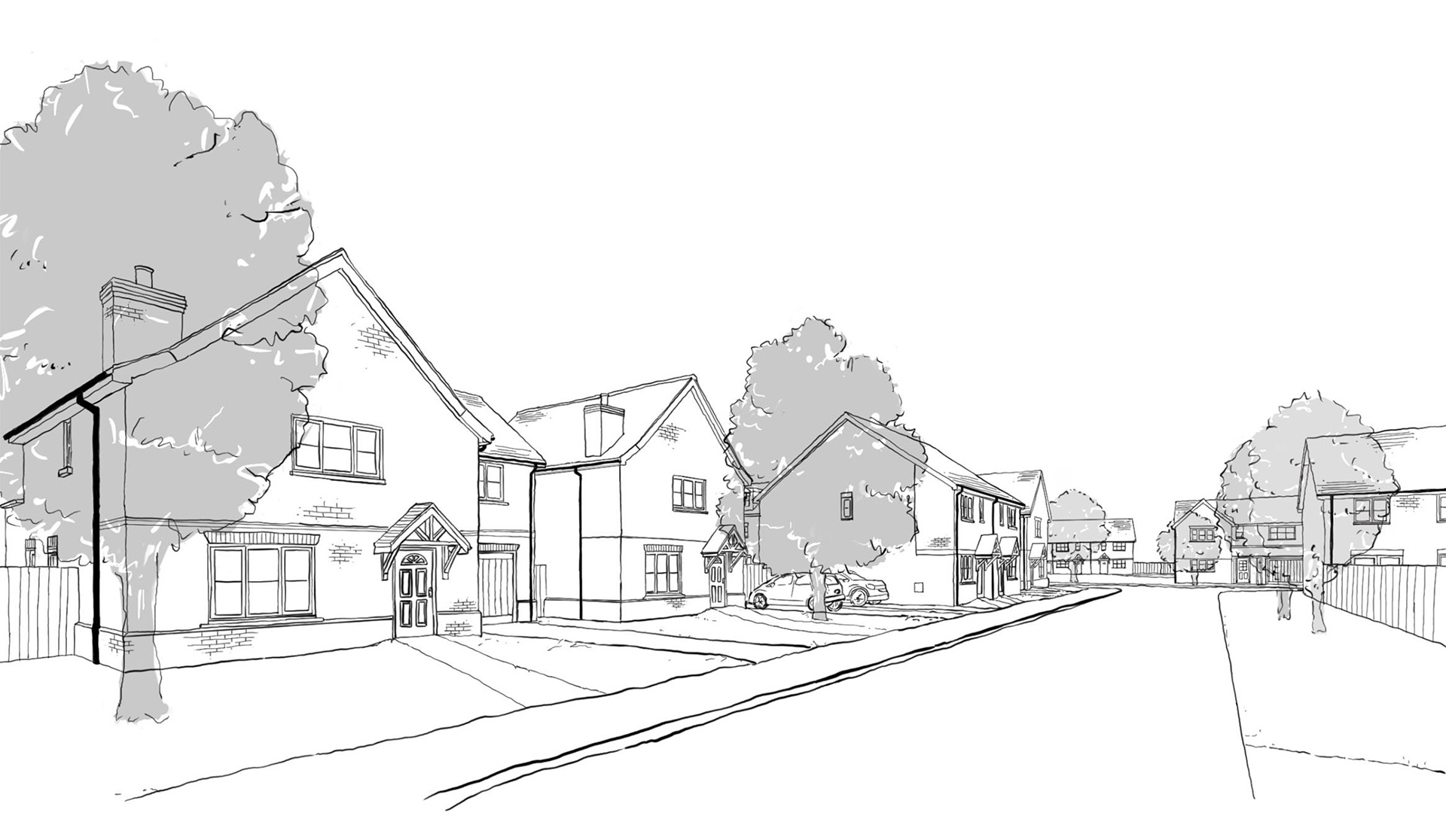
- Implementing a traditional architectural style with design cues from the local area.
- Landscaping and biodiversity improvements, providing at least 10% biodiversity net gain.
- All homes will be heated by Air Source Heat Pumps rather than gas.
- Sustainable drainage principles will be utilised on site, improving the current on-site drainage.
A range of house types
Homes fit for everyone’s individual needs
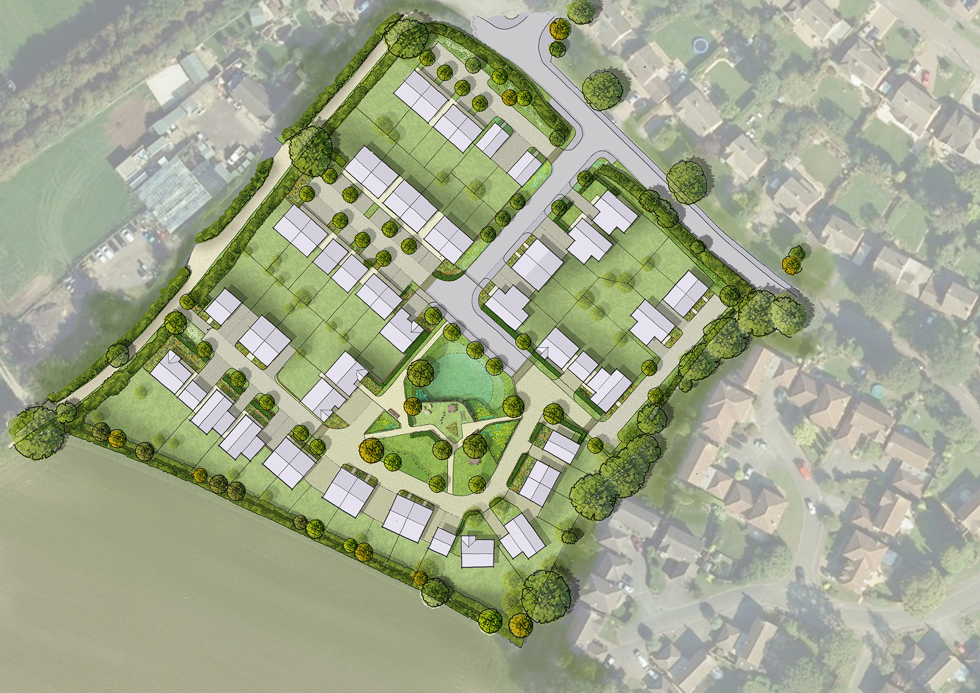
The draft allocation of the site identifies that an indicative figure of 65 homes could be delivered here. As part of our considered design approach, Hill Residential has tested different densities on the site to ensure that any development is sympathetic to its surroundings and the local context.
From this review, it is considered that circa 56 homes would provide a more sympathetic development, reflective of the local character.
The scheme encompasses a range of houses and low-rise apartment blocks, including circa 23 affordable housing units and circa 33 market housing units. This will enable more residents to get onto the housing ladder, including first-time buyers, families looking to upsize, or residents looking to downsize.
The proposals will provide a mixture of housing ranging from family housing to apartments, specifically a mix of 1 and 2 bed flats, and 2, 3 and 4/5 bed homes, with a maximum storey height of 2.5.
The design of the scheme is to have a traditional architectural expression with design cues taken from the local vernacular and inspiration taken from the immediate surrounding context.
Key architectural features will include gable end roof forms, tile hanging details, non-grounded chimney stacks, red & decorative brick, composite bay & dormer window types, and open porches.

Prioritising green open space
Creating vibrant community spaces, not just homes
We are committed to having a positive environmental impact on our developments, which also conforms to St Albans City & District Council’s sustainability goals.
As part of the proposals, the new development will deliver landscaped green open space for both new and existing residents to enjoy alongside the retention and enhancement of existing biodiversity through the following methods:
- A green space at the heart of the scheme to create a central community focus.
- Retention of all existing hedgerows, other than limited areas required for safe vehicular access and connections to the Nickey Line, provide natural visual screening from the open countryside.
- All existing trees to be retained on site including those under existing Tree Preservation Orders (TPO’s).
- Landscaping enhancement, particularly to northern and southern hedgerows.
- A minimum 10% biodiversity enhancement across the site.
- A new natural play area.
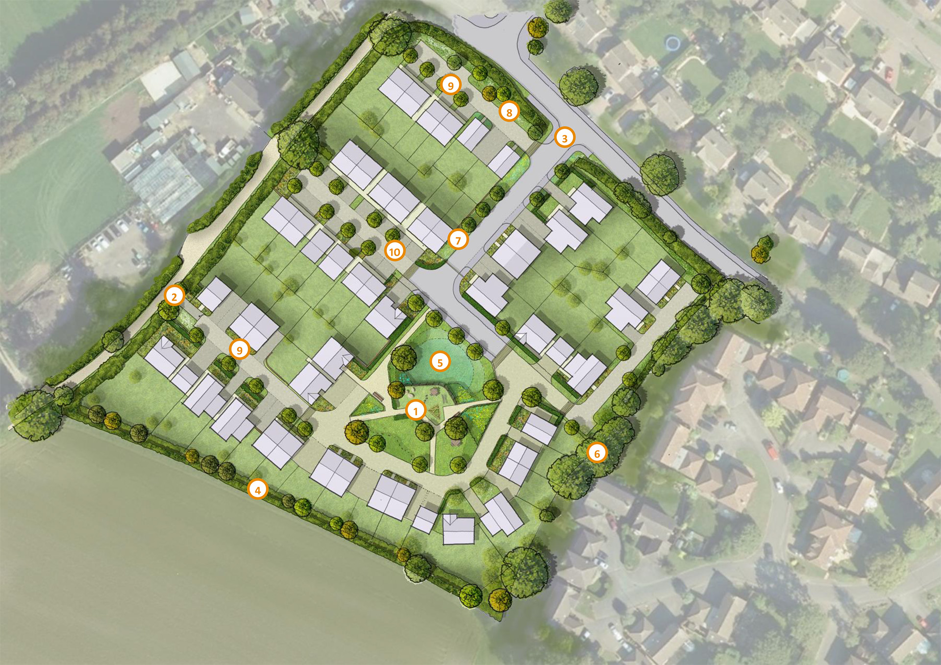
- 1Central greenspace
- 2Foot / cycle connections to the Nickey Line
- 3Vehicular access from Townsend Lane (selective hedgerow removal/thinning) to ensure sufficient visibility)
- 4Augmented vegetation on the southern boundary (supplementary mixed native hedgerow planting and hedgerow trees)
- 5Rainwater attenuation basin
- 6Existing structural planting retained
- 7Flowering lawn verges
- 8Landscape buffer / green edge – additional tree planting and long grass margins
- 9Low order, green streets
- 10Permeable block paving
Site access
Carefully designed access arrangements
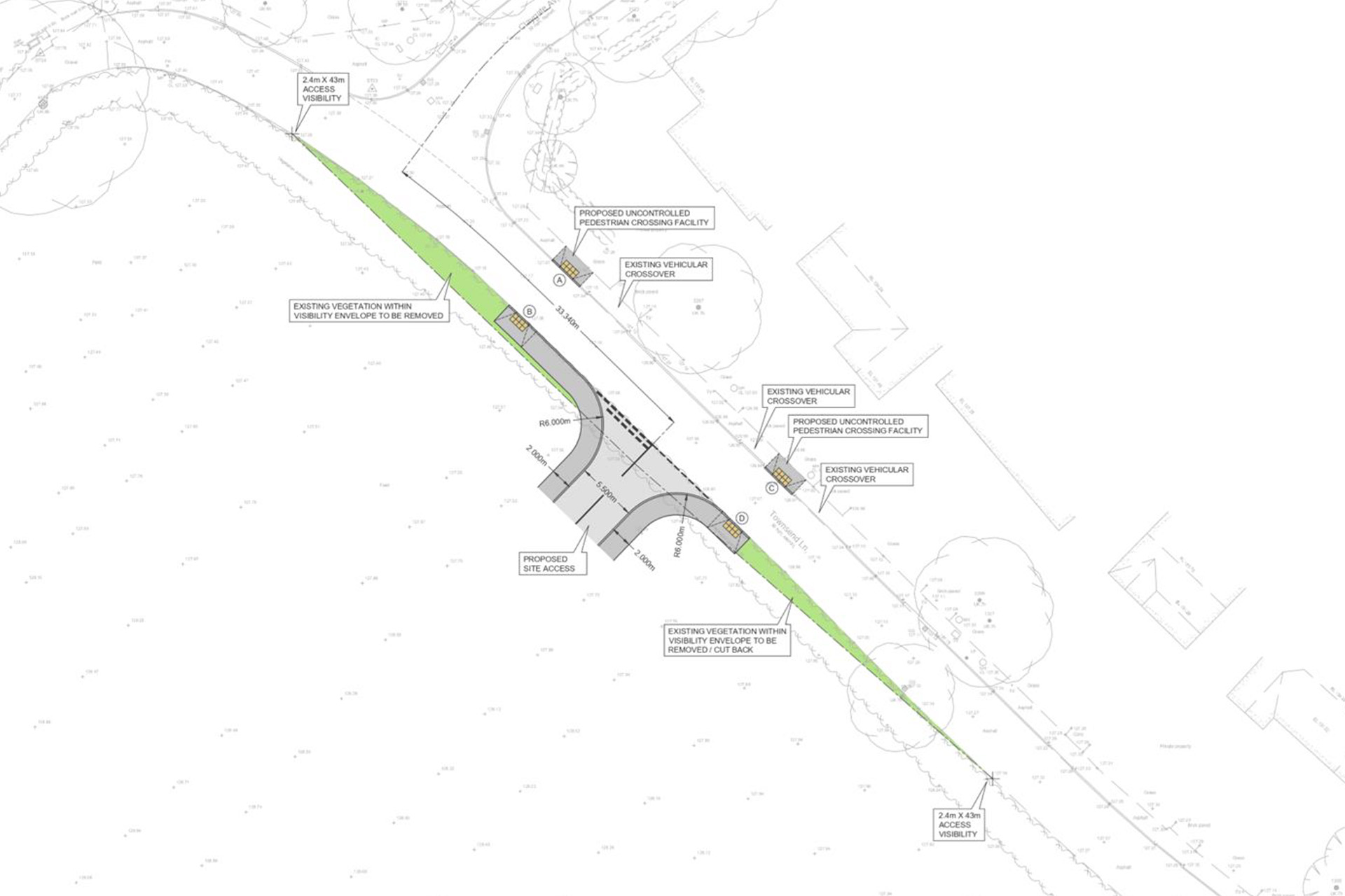
The development will be accessed via one primary vehicular access point off Townsend Lane.
The proposed road would be 5.5 metres wide and visibility at the junction has been planned in line with the 30 mph speed limit. The entrance is designed to allow refuse trucks to access the site, without needing to create an unnecessarily large junction.
The layout of road network within the site has been designed to reflect the existing street pattern along Townsend Lane, with organic internal roads to creating a softer, more informal character, encouraging a pedestrian-first approach.
Hill Residential have consulted with Hertfordshire County Council (HCC) on the proposed access arrangement into the site, HCC have confirmed that the Townsend Lane access is accepted in principle.
Commitment to sustainability
Sustainability is at the heart of our development strategy to support a sustainable future
The proposals have been developed with sustainability as a core principle, recognising St Albans City & District Council’s sustainability goals and climate emergency declaration. Hill Residential will utilise the following measures:
- Utilise a ‘Fabric First’ approach to new homes with u-values that exceed Building Regulations targets and will minimise carbon emissions.
- The development will be entirely gas-free and will incorporate renewable energy such as Air Source Heat Pumps.
- Promote sustainable travel and transport through enabling the use of public transport, with access to the existing local walking and cycle route network for enhanced sustainable transport connectivity.
- All homes will have access to one Electric Vehicle (EV) charging point point each and there will be provision for cycle storage to encourage the use of alternative modes of transport to the car.

Active travel
Fostering active living off Townsend Lane
Our development is designed with health and well-being at its core, providing numerous opportunities for residents to lead active and healthy lives.
The proposals incorporate cycling and walking routes to help promote cycling and walking as primary modes of transport, enhancing connectivity and reducing the reliance on cars for those living within the development.
Residents will be able to access the site through the creation of a new walking and cycling link from Townsend Lane to the southwest of the site. This access point will be for pedestrians and cyclists only and will allow for connection to the Nickey Line improving connectivity to the wider area and encouraging active travel.

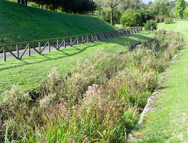
Flood mitigation
Sustainably designed surface water management to help prevent flooding
The proposals have been designed to effectively manage surface water. The proposed surface water drainage strategy will use sustainable urban drainage systems (SuDS) to capture, control and release water generated on-site, mimicking the current natural drainage with infiltration back into the ground in accordance with the drainage hierarchy.
The system will be designed to manage severe weather that happens very rarely, such as a 1-in-100-year storm event and to account for climate change and potential urban creep on the development.
The proposed SuDS features will be designed to also promote biodiversity and provide amenity benefits through an attractively planted detention basin, which will include new rich planted habitats.
Timeline
Overview of the proposals process
Timeline is subject to change due to planning and consultation.
Q3 2025
Launch of consultation
Q4 2025
Targeted submission of planning application
Q3 2026
Targeted determination of planning application